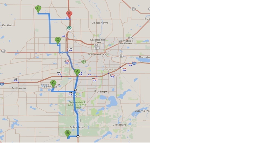
Addresses below are for your GPS. You can start at any letter and go down or up the list to continue the loop.
A. Start point: I-94 EB at Exit 74 A or I-94 WB at Exit 74 A.
B. Terry & Linda Gage 15887 Prairie Ronde Schoolcraft MI 49087
C. Arleigh Symyrnios 1209 E. Crooked Lake Dr. Kalamazoo, MI 49009
D. Gary & Lois Neidert 7014 Oak Highlands Kalamazoo, MI 49009
E. Bill & Sue Binning 9140 West C Ave. Kalamazoo, MI 49009
*Note GPS will not be correct for this address. It is 1.1 miles west of N 6th Street.
F. End Point: US-131 SB or US-131 NB. Note: Rest Area w/Facilities on US-131 SB just south of Exit 44
Garden “B” Terry and Linda Gage
The Gage gardens reside on a rural neighborhood lot, in sweeping beds of hosta and companion plants. Terry is a hosta collector and amateur hybridizer. He has over 800 varieties and creates his own crosses by outsmarting the bees at dawn and gathering pollen. His efforts have created hundreds of seedlings that may or may not make the cut. He has registered and named one favorite, H. Supreme Court Justice. Peek behind the large spruce in the back to see his raised bed seedlings.
A new interest in unusual conifers can be seen on a berm in one of the few sunny areas of the yard. Some daylilies, hydrangea and other sun loving perennials gather in backyard islands, keeping vases full in summer.
We hope you enjoy the wandering calm and serenity of the landscape.
From Starting Point “A” to Garden “B”
Total Distance: 13.4 miles; Total time: 16 Minutes.
From I-94 WB or I-94 EB.
- Take Exit 74 A to merge onto US-131 S toward Three Rivers. Drive for 10.5 miles.
- Turn right onto West XY Ave. – Drive for 1.3 miles.
- Turn left onto S. 11th – Drive for 0.3 miles.
- Turn right onto Wood Brook St. – Drive 0.2 miles.
- Turn left onto Prairie Ronde and it is the 1st house on the left on the corner.
Destination “B”: 15887 Prairie Ronde Schoolcraft, MI 49087
Garden “C” Arleigh Symyrnios
Welcomes you to my addiction! This fan-shaped lake property has 360 feet of shoreline and over 200 feet of road frontage. It is loaded with garden beds varying from full sun to shade, containing thousands of plants of many varieties. Most of the plants are labeled for those who are curious.
The shade beds lie under a raised canopy of tall oak, maple and hickory trees and are home to over 1100 hostas, as well as hundreds of other shade plant varieties. This is my personal favorite area.
There is no linear way to walk through these garden beds. All beds aren’t in sight of each other, and there are multiple levels on the property. You just have to wander or you’ll miss something, such as the 60’ rain garden near the western beach area.
There are benches scattered around if you should need a rest along the way.
From Garden “B” to Garden “C”
Total Distance: 13.3 miles; Total time: 20 Minutes
- Head northwest on Prairie Ronde St. toward Wood Brook St.
- Turn right onto Wood Brook St – Drive for .2 miles.
- Turn left onto S. 11th – Drive for 0.3 miles.
- Turn right onto West XY Ave. – Drive for 1.3 miles.
- Turn left onto US-131 N – Drive for 7.2 miles.
- Take Exit 31 to West Centre Ave. toward Portage – Drive for 0.3 miles.
- Turn left onto West Centre Ave. – Drive 0.2 miles.
- Continue onto West Q Ave. – Drive for 3.2 miles.
- Turn right onto S. 7th – Drive for a short distance.
- Turn right onto E. Crooked Lake Dr. – Drive for 0.6 miles
Destination “C”: 1209 E. Crooked Lake Dr. Kalamazoo, MI 49009
Garden “D” Gary and Lois Neidert
The Neidert home sits on a hill surrounded by oak, maple and native dogwood trees. For the past 23 years, Gary and Lois have been gradually converting the area into a series of gardens. A hillside garden greets the visitor at the front of the property. Shade gardens along the driveway beckon one up the hill to see hosta gardens and junipers cascading over the large boulder walls.
A garden arch begins the path that winds past the miniature hosta garden, around the koi water garden toward the wooded hosta areas. Although there are a wide variety of shade loving plants, the 1200+ hostas dominate the gardens. “Hosta Highlands” has over 800 labeled hosta cultivars displayed as accents, specimens and groundcover. The hilly terrain allows both up-close inspections as well as panoramic views of the ways hostas can be used to brighten and accentuate the shade garden.
From Garden “C” to Garden “D”
Total Distance: 13.3 miles; Total time: 18 Minutes
- Head southwest on E. Crooked Lake Dr. toward S. 7th St. – Drive for 0.6 miles.
- Turn left onto S. 7th St. – Drive for a short distance.
- Turn left onto West Q Ave – Drive for 2.9 miles.
- Continue onto West Centre Ave. – Drive 0.2 miles.
- Turn left onto US-131 N toward Kalamazoo – Drive for 2.7 miles.
- Continue onto I-94 BLE / US-131 N – Drive for 1.9 miles.
- Continue onto US-131 N – Drive 2.5 miles
- Take exit 36 B for M-43 W toward South Haven – Drive 0.2 miles.
- Merge onto M-43 – Drive for 0.9 miles.
- Turn right onto N 9th – Drive for 1.2 miles.
- Turn left onto Oak Highlands Dr. – Drive for 0.2 mile.
Destination “D”: 7014 Oak Highlands Kalamazoo, MI 49009
Garden E” Bill & Sue Binning
The Binning Garden is located in the heart of a farming community. The hosta garden started with a few hostas planted around some maple trees. The garden has evolved over the last 15 years, and today it has many varieties of hostas. In addition, you will see sun perennials, ornamental trees, shrubs, raised bed vegetable garden, and a small waterfall feature. Most of the fieldstone used in the landscape has been gathered from the surrounding farm fields. Wandering through the garden you will also see some unique garden art adding interest to the area.
From Garden “D” to Garden “E”
Total Distance: 8.2 miles: Total time: 13 Minutes
- Head east on Oak Highlands Dr. toward N 9th Street – Drive for .2 miles.
- Turn left onto N 9th – Drive for 0.3 miles.
- Turn left onto West H Ave. – Drive for 1.2 miles.
- Turn right onto N 6th Street. – Drive for 5.0 miles.
- Turn left onto West C Ave. – Drive for 1.1 miles.
Destination “F”: 9140 West C Ave. Kalamazoo, MI 49009
From Garden “E” to “F” (US-131 SB or US-131 NB)
Total Distance: 4.9 miles: Total time: 10 Minutes
Head east on West C Ave. toward N 6th St – Drive for 1.1 miles*.
- Turn right onto N 6th St. – Drive for 1.0 miles.
- Turn left onto West D Ave. – Drive for 2.5 miles.
- Follow the signs to get US-131 S or US-131 N
Destination: Home